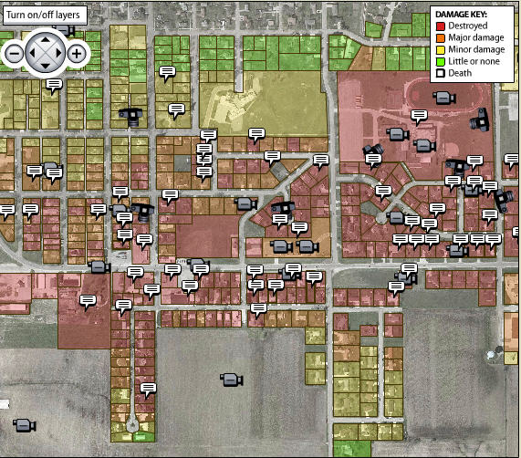
Parkersburg Tornado
On May 25, 2008, an EF-5 tornado — that’s a big one — swept through the Parkersburg, Iowa, area, killing nine, injuring 70 and decimating the south side of the town. In the week after, we went to work documenting the damage. I started building a parcel map, screen-shotting a map on the Butler County assessor’s website, then tracing the boundaries in Illustrator. Another graphic artist drove to Parkersburg and walked every street hit by the tornado, taking an “after” photo and recording the address. We then looked up each of those addresses on the assessor’s site and saved a “before” photo. I imported my parcel map into Flash, drew shapes for each parcel, then hooked them up to the data we had for each property. Click on a shape and we showed you before and after photos, and in some cases, a video, such as footage captured by a bank’s CCTV when the storm hit.
The project went on to gather great acclaim, garnering an honorable menthion in the prestigious Knight-Batten award competition honorinbg innovations in journalism. I really wish I could share the interactive with you, but as noted, it was built in Flash, and Flash just went away, along with a good chunk of the work I did for the Register while making the transition from graphic artist to developer. I’ve thought about someday trying to recreate the Parkersburg app using modern web technologies, just as an exercise. Perhaps someday I’ll do that.